The World Map: Types, Uses, and Modern Advances...!!!
World maps are indispensable tools that have evolved over time to meet the needs of various users.
Introduction
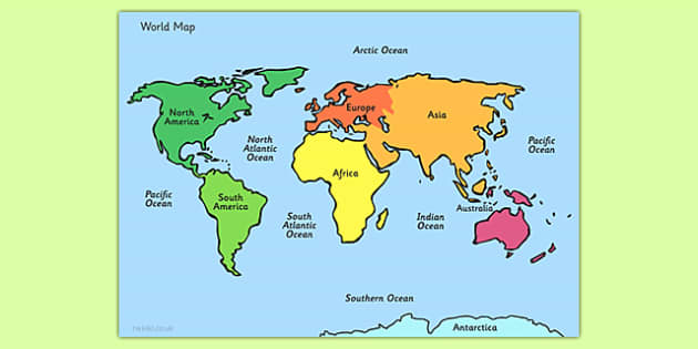
A world map is a depiction of the Earth's surface, illustrating the arrangement of continents, countries, oceans, and other key geographical features. World maps are essential tools in geography, navigation, education, and various fields requiring a spatial understanding of the planet. They come in different forms, such as physical maps, political maps, and thematic maps, each serving unique purposes.
Types of World Maps
-
Physical Maps
-
Description: Physical maps illustrate natural features like mountains, rivers, deserts, and oceans.
-
Uses: These maps are valuable for understanding the Earth's topography and natural landscapes. They assist geographers, geologists, and environmental scientists in studying natural phenomena and landforms.
-
-
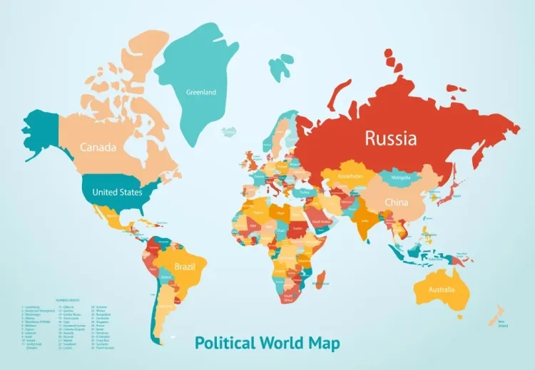
Political Maps
-
Description: Political maps highlight boundaries between countries, states, and territories, along with major cities and capitals.
-
Uses: These maps are crucial for comprehending political boundaries, governance, and territorial divisions. They are widely used in education, international relations, and travel planning.
-
-
Thematic Maps
-
Description: Thematic maps focus on specific themes or topics, such as population density, climate, economic activities, or natural resources.
-
Uses: These maps are valuable for researchers, policymakers, and planners who need to analyze specific data and trends. They aid in visualizing patterns and distributions related to various themes.
-
Uses of World Maps
-
Education
-
Geographical Knowledge: World maps are fundamental tools in classrooms, teaching students about geography, continents, countries, and major physical features.
-
Cultural Awareness: They promote an understanding of different cultures and regions, fostering global awareness and appreciation.
-
-
Navigation and Travel
-
Route Planning: World maps assist travelers and navigators in planning routes, identifying destinations, and understanding distances.
-
Exploration: Historically, world maps were crucial for explorers in discovering new lands and charting unknown territories.
-
-
Research and Analysis
-
Environmental Studies: Scientists use physical maps to study natural features, climate patterns, and environmental changes.
-
Economic Analysis: Thematic maps help economists analyze trade routes, resource distribution, and economic activities across different regions.
-
-
Policy and Governance
-
International Relations: Political maps are essential for diplomats and policymakers in understanding geopolitical boundaries and conducting international negotiations.
-
Resource Management: Governments use maps to manage natural resources, plan infrastructure, and develop regional policies.
-
-
Emergency Response
-
Disaster Management: In times of natural disasters, world maps help emergency responders identify affected areas, plan rescue operations, and coordinate relief efforts.
-
Humanitarian Aid: Organizations use maps to distribute aid, assess needs, and monitor the impact of humanitarian interventions.
-
-
Cultural and Historical Studies
-
Historical Analysis: Historians use old world maps to study historical events, trade routes, and territorial changes over time.
-
Cultural Mapping: Maps can highlight cultural landmarks, heritage sites, and regions of historical significance.
-
Modern Advances in World Mapping
-
Digital Maps
-
Interactive Features: Modern digital maps, such as those provided by GPS systems and online mapping services, offer interactive features for real-time navigation and information.
-
Accessibility: Digital maps are easily accessible on smartphones, computers, and other devices, making them convenient for everyday use.
-
-
Geographic Information Systems (GIS)
-
Data Integration: GIS technology allows for the integration of various data layers, enabling detailed spatial analysis and visualization.
-
Applications: GIS is used in urban planning, environmental management, transportation, and many other fields to make informed decisions based on spatial data.
-
World maps are indispensable tools that have evolved over time to meet the needs of various users. From physical and political maps to thematic and digital maps, they provide valuable insights into the Earth's geography, political boundaries, and thematic distributions. Whether in education, research, navigation, policy-making, or emergency response, world maps play a crucial role in shaping our understanding of the world and aiding in decision-making processes.
What's Your Reaction?